PolarStream: Streaming Lidar Object Detection and Segmentation with Polar Pillars
Paper and Code
Jun 14, 2021


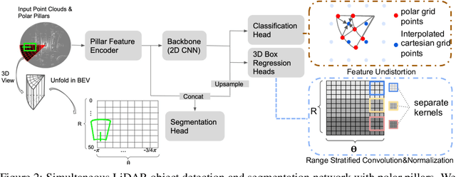
Recent works recognized lidars as an inherently streaming data source and showed that the end-to-end latency of lidar perception models can be reduced significantly by operating on wedge-shaped point cloud sectors rather then the full point cloud. However, due to use of cartesian coordinate systems these methods represent the sectors as rectangular regions, wasting memory and compute. In this work we propose using a polar coordinate system and make two key improvements on this design. First, we increase the spatial context by using multi-scale padding from neighboring sectors: preceding sector from the current scan and/or the following sector from the past scan. Second, we improve the core polar convolutional architecture by introducing feature undistortion and range stratified convolutions. Experimental results on the nuScenes dataset show significant improvements over other streaming based methods. We also achieve comparable results to existing non-streaming methods but with lower latencies.
 Add to Chrome
 Add to Firefox
 Add to Edge