 Add to Chrome
 Add to Firefox
 Add to Edge
Geographical hotspot prediction based on point cloud-voxel-community partition clustering
Paper and Code
Mar 27, 2025

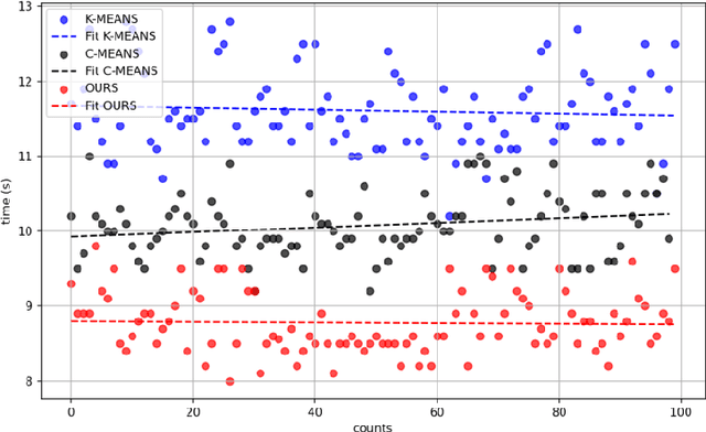

Existing solutions to the hotspot prediction problem in the field of geographic information remain at a relatively preliminary stage. This study presents a novel approach for detecting and predicting geographical hotspots, utilizing point cloud-voxel-community partition clustering. By analyzing high-dimensional data, we represent spatial information through point clouds, which are then subdivided into multiple voxels to enhance analytical efficiency. Our method identifies spatial voxels with similar characteristics through community partitioning, thereby revealing underlying patterns in hotspot distributions. Experimental results indicate that when applied to a dataset of archaeological sites in Turkey, our approach achieves a 19.31% increase in processing speed, with an accuracy loss of merely 6%, outperforming traditional clustering methods. This method not only provides a fresh perspective for hotspot prediction but also serves as an effective tool for high-dimensional data analysis.