Estimating snow cover from publicly available images
Paper and Code
Aug 05, 2015


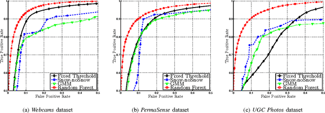
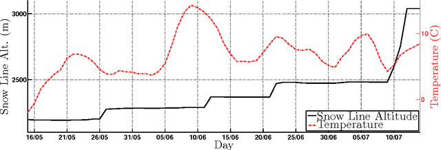
In this paper we study the problem of estimating snow cover in mountainous regions, that is, the spatial extent of the earth surface covered by snow. We argue that publicly available visual content, in the form of user generated photographs and image feeds from outdoor webcams, can both be leveraged as additional measurement sources, complementing existing ground, satellite and airborne sensor data. To this end, we describe two content acquisition and processing pipelines that are tailored to such sources, addressing the specific challenges posed by each of them, e.g., identifying the mountain peaks, filtering out images taken in bad weather conditions, handling varying illumination conditions. The final outcome is summarized in a snow cover index, which indicates for a specific mountain and day of the year, the fraction of visible area covered by snow, possibly at different elevations. We created a manually labelled dataset to assess the accuracy of the image snow covered area estimation, achieving 90.0% precision at 91.1% recall. In addition, we show that seasonal trends related to air temperature are captured by the snow cover index.
 Add to Chrome
 Add to Firefox
 Add to Edge