 Add to Chrome
 Add to Firefox
 Add to Edge
Cooperative Highway Work Zone Merge Control based on Reinforcement Learning in A Connected and Automated Environment
Jan 21, 2020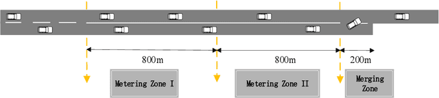

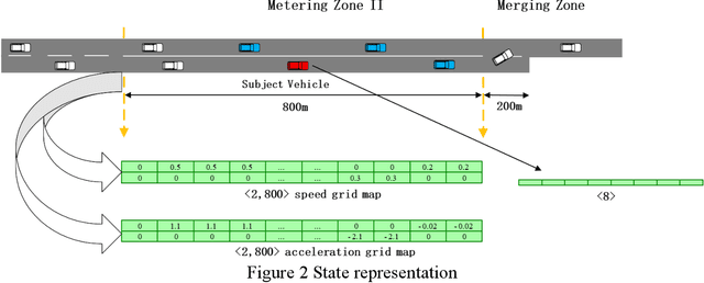

Given the aging infrastructure and the anticipated growing number of highway work zones in the United States, it is important to investigate work zone merge control, which is critical for improving work zone safety and capacity. This paper proposes and evaluates a novel highway work zone merge control strategy based on cooperative driving behavior enabled by artificial intelligence. The proposed method assumes that all vehicles are fully automated, connected and cooperative. It inserts two metering zones in the open lane to make space for merging vehicles in the closed lane. In addition, each vehicle in the closed lane learns how to optimally adjust its longitudinal position to find a safe gap in the open lane using an off-policy soft actor critic (SAC) reinforcement learning (RL) algorithm, considering the traffic conditions in its surrounding. The learning results are captured in convolutional neural networks and used to control individual vehicles in the testing phase. By adding the metering zones and taking the locations, speeds, and accelerations of surrounding vehicles into account, cooperation among vehicles is implicitly considered. This RL-based model is trained and evaluated using a microscopic traffic simulator. The results show that this cooperative RL-based merge control significantly outperforms popular strategies such as late merge and early merge in terms of both mobility and safety measures.
A Deep Neural Networks Approach for Pixel-Level Runway Pavement Crack Segmentation Using Drone-Captured Images
Jan 09, 2020
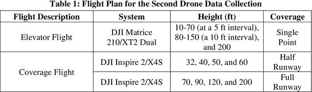
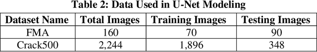
Pavement conditions are a critical aspect of asset management and directly affect safety. This study introduces a deep neural network method called U-Net for pavement crack segmentation based on drone-captured images to reduce the cost and time needed for airport runway inspection. The proposed approach can also be used for highway pavement conditions assessment during off-peak periods when there are few vehicles on the road. In this study, runway pavement images are collected using drone at various heights from the Fitchburg Municipal Airport (FMA) in Massachusetts to evaluate their quality and applicability for crack segmentation, from which an optimal height is determined. Drone images captured at the optimal height are then used to evaluate the crack segmentation performance of the U-Net model. Deep learning methods typically require a huge set of annotated training datasets for model development, which can be a major obstacle for their applications. An online annotated pavement image dataset is used together with the FMA data to train the U-Net model. The results show that U-Net performs well on the FMA testing data even with limited FMA training images, suggesting that it has good generalization ability and great potential to be used for both airport runways and highway pavements.