 Add to Chrome
 Add to Firefox
 Add to Edge
Augmented Semantic Signatures of Airborne LiDAR Point Clouds for Determining Change in Time-varying Data
Apr 29, 2020
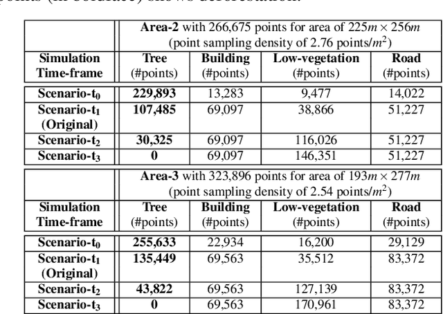

LiDAR point clouds provide rich geometric information, which is particularly useful for the analysis of complex scenes of urban regions. Finding structural and semantic differences between two different three-dimensional point clouds, say, of the same region but acquired at different time instances is an important problem. Usually, the data capture has inconsistencies when taken at different time instances, e.g., sampling densities, and the orientation of the flight path. Hence, change detection involves computationally expensive registration and segmentation. We are interested in capturing the relative differences in the geometric uncertainty and semantic content of the point cloud without the registration process. Hence, we propose an orientation-invariant geometric signature of the point cloud, which integrates its probabilistic geometric and semantic classifications. We study different properties of the geometric signature, which are image-based encoding of geometric uncertainty and semantic content. We explore different metrics to determine differences between these signatures, which in turn compare point clouds without performing point-to-point registration. We have observed that a point cloud with four semantic classes, namely, buildings, trees, road, and low-vegetation, that the tree class shows a characteristic pattern. Thus, we use a case study of airborne LiDAR point clouds where the visual and the quantitative comparisons of the geometric signatures of point clouds are useful in demonstrating changes during a thematic event, such as progressive deforestation, in the topography of an urban region. Our results show that the differences in the signatures corroborate with the geometric and semantic differences of the point clouds.