María Castrillo
Personalized Federated Learning for improving radar based precipitation nowcasting on heterogeneous areas
Aug 11, 2024Abstract:The increasing generation of data in different areas of life, such as the environment, highlights the need to explore new techniques for processing and exploiting data for useful purposes. In this context, artificial intelligence techniques, especially through deep learning models, are key tools to be used on the large amount of data that can be obtained, for example, from weather radars. In many cases, the information collected by these radars is not open, or belongs to different institutions, thus needing to deal with the distributed nature of this data. In this work, the applicability of a personalized federated learning architecture, which has been called adapFL, on distributed weather radar images is addressed. To this end, given a single available radar covering 400 km in diameter, the captured images are divided in such a way that they are disjointly distributed into four different federated clients. The results obtained with adapFL are analyzed in each zone, as well as in a central area covering part of the surface of each of the previously distributed areas. The ultimate goal of this work is to study the generalization capability of this type of learning technique for its extrapolation to use cases in which a representative number of radars is available, whose data can not be centralized due to technical, legal or administrative concerns. The results of this preliminary study indicate that the performance obtained in each zone with the adapFL approach allows improving the results of the federated learning approach, the individual deep learning models and the classical Continuity Tracking Radar Echoes by Correlation approach.
Estimation of high frequency nutrient concentrations from water quality surrogates using machine learning methods
Jan 27, 2020


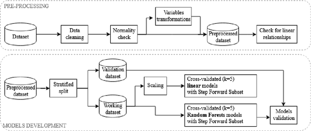
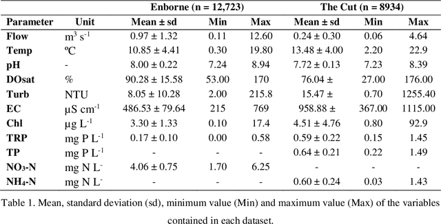
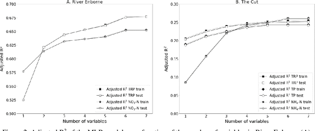
Abstract:Continuous high frequency water quality monitoring is becoming a critical task to support water management. Despite the advancements in sensor technologies, certain variables cannot be easily and/or economically monitored in-situ and in real time. In these cases, surrogate measures can be used to make estimations by means of data-driven models. In this work, variables that are commonly measured in-situ are used as surrogates to estimate the concentrations of nutrients in a rural catchment and in an urban one, making use of machine learning models, specifically Random Forests. The results are compared with those of linear modelling using the same number of surrogates, obtaining a reduction in the Root Mean Squared Error (RMSE) of up to 60.1%. The profit from including up to seven surrogate sensors was computed, concluding that adding more than 4 and 5 sensors in each of the catchments respectively was not worthy in terms of error improvement.
 Add to Chrome
 Add to Firefox
 Add to Edge