 Add to Chrome
 Add to Firefox
 Add to Edge
STF-GCN: A Multi-Domain Graph Convolution Network Method for Automatic Modulation Recognition via Adaptive Correlation
Apr 11, 2025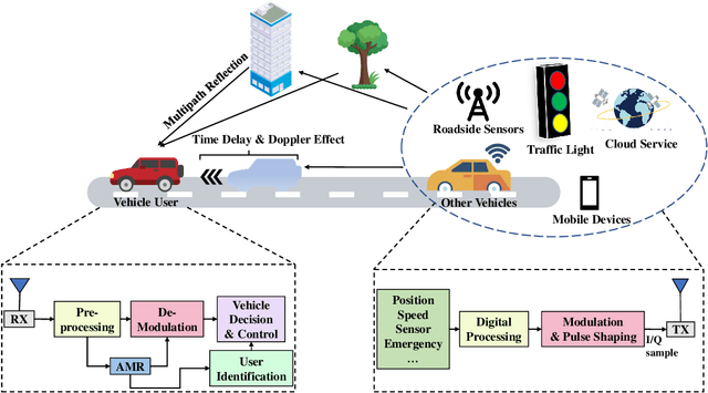
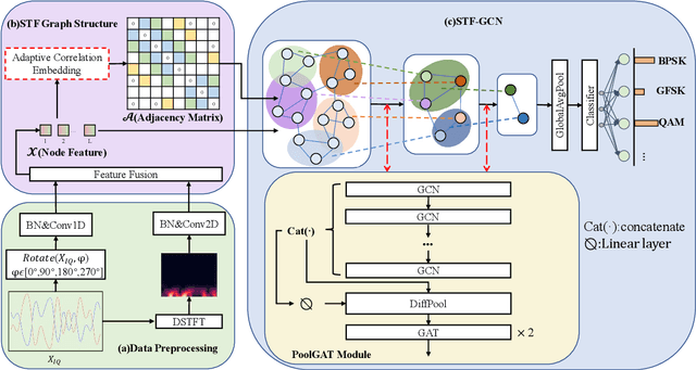
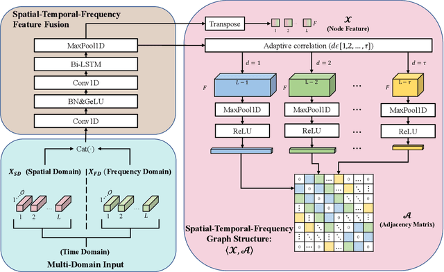
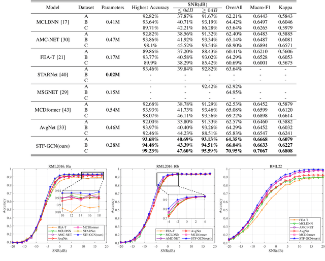
Automatic Modulation Recognition (AMR) is an essential part of Intelligent Transportation System (ITS) dynamic spectrum allocation. However, current deep learning-based AMR (DL-AMR) methods are challenged to extract discriminative and robust features at low signal-to-noise ratios (SNRs), where the representation of modulation symbols is highly interfered by noise. Furthermore, current research on GNN methods for AMR tasks generally suffers from issues related to graph structure construction and computational complexity. In this paper, we propose a Spatial-Temporal-Frequency Graph Convolution Network (STF-GCN) framework, with the temporal domain as the anchor point, to fuse spatial and frequency domain features embedded in the graph structure nodes. On this basis, an adaptive correlation-based adjacency matrix construction method is proposed, which significantly enhances the graph structure's capacity to aggregate local information into individual nodes. In addition, a PoolGAT layer is proposed to coarsen and compress the global key features of the graph, significantly reducing the computational complexity. The results of the experiments confirm that STF-GCN is able to achieve recognition performance far beyond the state-of-the-art DL-AMR algorithms, with overall accuracies of 64.35%, 66.04% and 70.95% on the RML2016.10a, RML2016.10b and RML22 datasets, respectively. Furthermore, the average recognition accuracies under low SNR conditions from -14dB to 0dB outperform the state-of-the-art (SOTA) models by 1.20%, 1.95% and 1.83%, respectively.
Effective Cloud Detection and Segmentation using a Gradient-Based Algorithm for Satellite Imagery; Application to improve PERSIANN-CCS
Sep 27, 2018


Being able to effectively identify clouds and monitor their evolution is one important step toward more accurate quantitative precipitation estimation and forecast. In this study, a new gradient-based cloud-image segmentation technique is developed using tools from image processing techniques. This method integrates morphological image gradient magnitudes to separable cloud systems and patches boundaries. A varying scale-kernel is implemented to reduce the sensitivity of image segmentation to noise and capture objects with various finenesses of the edges in remote-sensing images. The proposed method is flexible and extendable from single- to multi-spectral imagery. Case studies were carried out to validate the algorithm by applying the proposed segmentation algorithm to synthetic radiances for channels of the Geostationary Operational Environmental Satellites (GOES-R) simulated by a high-resolution weather prediction model. The proposed method compares favorably with the existing cloud-patch-based segmentation technique implemented in the PERSIANN-CCS (Precipitation Estimation from Remotely Sensed Information using Artificial Neural Network - Cloud Classification System) rainfall retrieval algorithm. Evaluation of event-based images indicates that the proposed algorithm has potential to improve rain detection and estimation skills with an average of more than 45% gain comparing to the segmentation technique used in PERSIANN-CCS and identifying cloud regions as objects with accuracy rates up to 98%.