 Add to Chrome
 Add to Firefox
 Add to Edge
Subnational Geocoding of Global Disasters Using Large Language Models
Nov 13, 2025Subnational location data of disaster events are critical for risk assessment and disaster risk reduction. Disaster databases such as EM-DAT often report locations in unstructured textual form, with inconsistent granularity or spelling, that make it difficult to integrate with spatial datasets. We present a fully automated LLM-assisted workflow that processes and cleans textual location information using GPT-4o, and assigns geometries by cross-checking three independent geoinformation repositories: GADM, OpenStreetMap and Wikidata. Based on the agreement and availability of these sources, we assign a reliability score to each location while generating subnational geometries. Applied to the EM-DAT dataset from 2000 to 2024, the workflow geocodes 14,215 events across 17,948 unique locations. Unlike previous methods, our approach requires no manual intervention, covers all disaster types, enables cross-verification across multiple sources, and allows flexible remapping to preferred frameworks. Beyond the dataset, we demonstrate the potential of LLMs to extract and structure geographic information from unstructured text, offering a scalable and reliable method for related analyses.
A monthly sub-national Harmonized Food Insecurity Dataset for comprehensive analysis and predictive modeling
Jan 13, 2025Food security is a complex, multidimensional concept challenging to measure comprehensively. Effective anticipation, monitoring, and mitigation of food crises require timely and comprehensive global data. This paper introduces the Harmonized Food Insecurity Dataset (HFID), an open-source resource consolidating four key data sources: the Integrated Food Security Phase Classification (IPC)/Cadre Harmonis\'e (CH) phases, the Famine Early Warning Systems Network (FEWS NET) IPC-compatible phases, and the World Food Program's (WFP) Food Consumption Score (FCS) and reduced Coping Strategy Index (rCSI). Updated monthly and using a common reference system for administrative units, the HFID offers extensive spatial and temporal coverage. It serves as a vital tool for food security experts and humanitarian agencies, providing a unified resource for analyzing food security conditions and highlighting global data disparities. The scientific community can also leverage the HFID to develop data-driven predictive models, enhancing the capacity to forecast and prevent future food crises.
Convolutional Neural Networks for Global Human Settlements Mapping from Sentinel-2 Satellite Imagery
Jun 05, 2020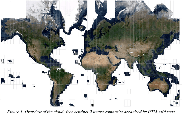
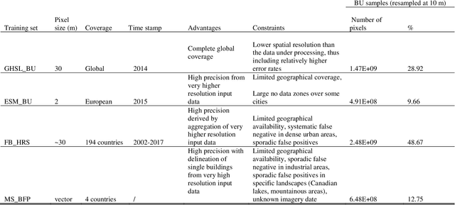
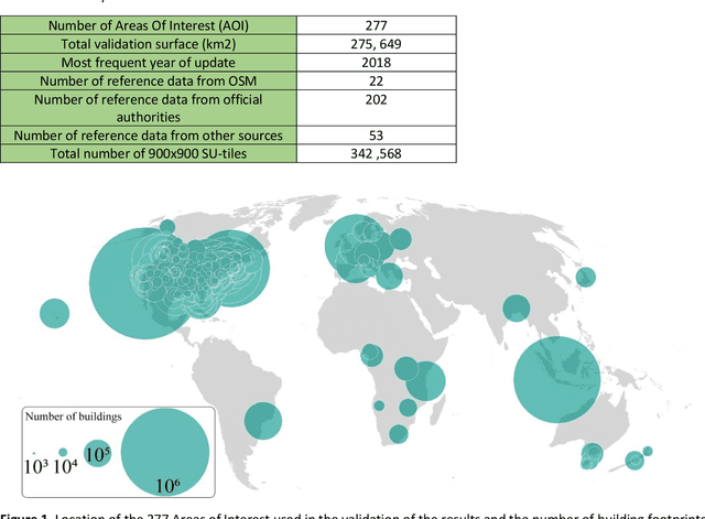

Spatially consistent and up-to-date maps of human settlements are crucial for addressing policies related to urbanization and sustainability especially in the era of an increasingly urbanized world. The availability of open and free Sentinel-2 data of the Copernicus Earth Observation programme offers a new opportunity for wall-to-wall mapping of human settlements at a global scale. This paper presents a deep-learning-based framework for a fully automated extraction of built-up areas at a spatial resolution of 10 meters from a global composite of Sentinel-2 imagery. A multi-neuro modelling methodology, building on a simple Convolution Neural Networks architecture for pixel-wise image classification of built-up areas is developed. The deployment of the model on the global Sentinel-2 image composite provides the most detailed and complete map reporting about built-up areas for reference year 2018. The validation of the results with an independent reference dataset of building footprints covering 277 sites across the world, establishes the reliability of the built-up layer produced by the proposed framework and the model robustness. The results of this study contribute to cutting-edge research in the field of automated built-up areas mapping from remote sensing data and establish a new reference layer for the analysis of the spatial distribution of human settlements across the rural-urban continuum