Towards an Automatic System for Extracting Planar Orientations from Software Generated Point Clouds
Paper and Code
Dec 22, 2020


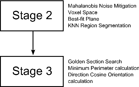
In geology, a key activity is the characterisation of geological structures (surface formation topology and rock units) using Planar Orientation measurements such as Strike, Dip and Dip Direction. In general these measurements are collected manually using basic equipment; usually a compass/clinometer and a backboard, recorded on a map by hand. Various computing techniques and technologies, such as Lidar, have been utilised in order to automate this process and update the collection paradigm for these types of measurements. Techniques such as Structure from Motion (SfM) reconstruct of scenes and objects by generating a point cloud from input images, with detailed reconstruction possible on the decimetre scale. SfM-type techniques provide advantages in areas of cost and usability in more varied environmental conditions, while sacrificing the extreme levels of data fidelity. Here is presented a methodology of data acquisition and a Machine Learning-based software system: GeoStructure, developed to automate the measurement of orientation measurements. Rather than deriving measurements using a method applied to the input images, such as the Hough Transform, this method takes measurements directly from the reconstructed point cloud surfaces. Point cloud noise is mitigated using a Mahalanobis distance implementation. Significant structure is characterised using a k-nearest neighbour region growing algorithm, and final surface orientations are quantified using the plane, and normal direction cosines.
 Add to Chrome
 Add to Firefox
 Add to Edge